![]()
![]()
![]()
![]()
![]()
...
...
...
...
...
...
...
...
...
...
..
...
...
...
...
...
...
...
...
...
...
...
...
Flipside
Clementine
Perpetual Motion
Possible
World
...
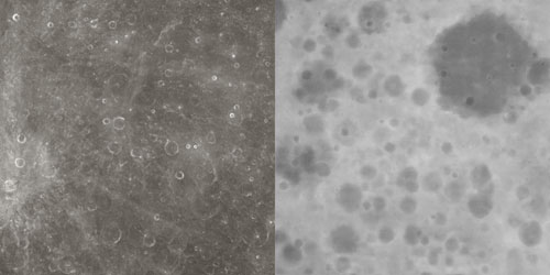
Maps of the lunar far side (c. 135°)
Image map based on the Clementine UVVIS 750nm basemap (left)
Corresponding displacement map based on Cook's DEM (right)
The animation incorporates scientific data collected by US Department of Defense / NASA’s Clementine spacecraft which spent several months orbiting the moon in 1994 and generated nearly two million photographic 'tiles' of the lunar surface. As part of a project that followed the Strategic Defense Initiative or 'Stars Wars' programme of the 1980s, Clementine was primarily aimed at testing equipment for tracking ballistic missiles. The US Department of Defense, however, was persuaded to incorporate a lunar mapping dimension to the project and in many respects this is what the spacecraft is remembered for, in a sense outlasting the defense programme of which it was a part.
In the animation, the lunar terrain is created using both image maps based on the original Clementine data (maintained by the USGS) and displacement maps based on a digital elevation model (DEM) developed by Dr Anthony Cook from the Clementine data. The range of grayscale values in the displacement map (above right) corresponds to the height of the moon's surface at a particular point: the lighter the tone, the higher the terrain and vice versa. The image on the left shows the corresponding area of the moon and is an adjusted version based on some of the original Clementine photographs.
As Clementine orbited the moon and took photographs at set intervals, there was necessarily a degree of overlap in the coverage of these photographic 'tiles'. Cook used a stereo-matching process on the overlaps in order to extract height data, a technique related to stereo photogrammetry, the principles of which predate the invention of photography itself. Given the partial coverage afforded by these overlaps, Cook's DEM contains areas of detail alternating with sections where there is a complete absence of information. Despite this incompleteness - an inherent limitation in the available data - his work offers a useful and as yet unsurpassed model of the moon's terrain.
Thanks to Dr Anthony Cook, Aberystwyth University.
![]()